


Albuquerque, New Mexico
New Mexico is one of the 50 United States of America (on the flag, we're star number 47 at the lower right), so you don't need a visa to come visit! Albuquerque straddles the Rio Grande (Spanish for Grand or Great River) in central New Mexico. While the river is breathtaking at the Rio Grande Gorge in northern New Mexico, most times of the year in Albuquerque, it's just a muddy trickle with most of the water being diverted to irrigation channels. Albuquerque sprawls over more than 100 square miles at elevations ranging from 4,500 feet above sea level in the Rio Grande Valley to 6,500 feet in the Sandia Mountain foothills. Albuquerque is the largest city in New Mexico, with about 500,000 residents in the city proper, and about 800,000 in the larger metropolitan area. In 1981, the city of Rio Rancho on the west side of Albuquerque was incorporated as an independent municipality. Albuquerque enjoys blue skies and sunshine 310 days a year, so is a mecca for outdoor activities.
The Sandia mountain range as viewed from Santa Anna Pueblo land.
Landscape
Sandia mountains from northeast Albuquerque
.jpg)
Sandia peak looking west (the Rio Grande and Albuquerque)
.jpg)
Sandia peak looking east
.jpg)
Five extinct volcanoes on Albuquerque's west mesa
.gif)
Mount Taylor in the distance
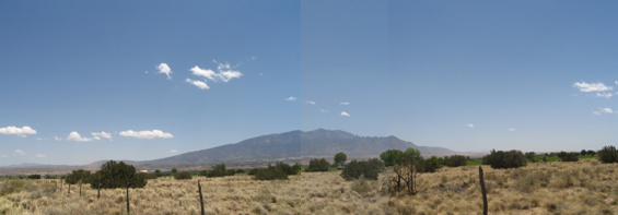
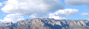
To the east of Albuquerque are the magnificent Sandia Mountains (summit at 10,378 feet) with a ski area and the world's longest aerial tramway (the Tram). Atop the crest, you can take in a panoramic view of more than 11,000 square miles. In the photo above at the extreme left, 60 miles in the distance near Santa Fe, New Mexico, is the southern end of the Sangre de Cristo mountains (Spanish for Blood of Christ). They are the southernmost subrange of the Rocky Mountains, and run up into Colorado. Albuquerque is also bordered to the east by the Manzano mountain range which runs 40 miles to the south. Driving into Albuquerque from places East, Interstate 40 (I-40) follows an ancient trail that runs through the pass between the Sandia and Manzano mountain ranges. I-40 continues on west to Arizona. Running north and south, I-25 intersects I-40 in Albuquerque.
To the immediate west of Albuquerque within the Petroglyph National Monument, five extinct volcanic cones rise above the high mesa. High school pranksters hauled a bunch of old tires into one of the cones and set them on fire in the 1950s, creating lots of smoke - and concern for some area residents. Sixty miles west of Albuquerque, near Grants, New Mexico, Mount Taylor is a massive, extinct volcano clearly visible from Albuquerque. It's real pretty when snow covers the peak. Mount Taylor is the high point (11,301 feet) of the San Mateo mountains in Cibola County. The mountain range was formed by the eruption of Mount Taylor and its prehistoric ancestors. Note there is an identically named mountain range in Socorro County south of Albuquerque. The north and south ends of Albuquerque are bordered by Sandia and Isleta Pueblo lands.
The following narrative plagiarizes freely from a multitude of sources including the 1999/2000 Albuquerque Yellow Pages (phone book), some writing on the back of an Albuquerque area restaurant menu, and the ever present Wikipedia and Google search. Some liberties have been taken in the retelling of history.
The Early Years
The Rio Grande Valley has been populated and cultivated as far back as 2000 B.C. The Petroglyph National Monument forms a 17-mile, north-south escarpment on Albuquerque's west side, containing more than 17,000 prehistoric Native American and historic Hispanic images scratched into the black volcanic boulders. This one site contains the world's largest accessible collection of prehistoric rock art. While some art was carved as long ago as 1000 B.C., most were created by prehistoric Pueblo Indian farmers beginning in A.D. 1300 when their civilization was at a peak. I think we call them prehistoric because "history" didn't really start until we started recording things in books and Kindles.
New Mexico is home to 19 Indian Pueblos and three Indian reservations. Most Pueblos are within an hour's drive of Albuquerque and some welcome visitors. Those interested in finding out more about the Indians of New Mexico should first visit the Indian Pueblo Cultural Center in Albuquerque.
Spanish Urban Renewal
The Albuquerque west mesa stone art extravaganza ended abruptly in 1540 when the Spanish conquistador, Francisco Vásquez de Coronado y Luján, invaded the territory. (His friends just called him Coronado, like the shopping mall in Albuquerque.) Many texts simply say he "visited" New Mexico - is that kind of like saying you "visited" your relatives in Ohio last summer? During the winter of 1540-41, Coronado holed up in a pueblo of Tiguex (uninvited guest), across the river from present-day Bernalillo (a community about 20 miles north of Albuquerque that is famous for its Labor Day weekend Wine Festival). The war that followed didn't go well for area inhabitants. Coronado hoped to conquer the fabled Seven Cities of Gold, also called Cibola. Upon hearing of a wealthy civilization called Quivira from an Indian guide, he set out from New Mexico in 1541 as far as present day Kansas. History suggests the guide's intention was to lead Coronado astray with the hope that he'd get lost in the wilderness. Coronado was a good boy scout, didn't get lost, and came back to visit New Mexico again December of 1541. He was no more the richer and much worse for wear.
Give it Back
Catholic missionaries built churches in several pueblos in the area around present day Albuquerque in the early 1600s. With the native inhabitants in decline (books have been written on that topic), Spanish colonists moved into the area, establishing estancias (farms). Things stayed pretty calm until the Pueblo Indian Revolt of 1680 which drove the settlers south to present day Juarez, Mexico. In 1692, Diego de Vargas Zapata y Luján Ponce de León y Contreras (it took him a long time to sign checks) re-entered New Mexico and took back Spanish control.
Founding of Albuquerque
We then find that Francisco Cuervo y Valdés was a very busy fellow. He was a Knight of Santiago for years (the Military Order of Saint James of the Sword), a Guadalajara treasury official, ruled some parts of Mexico, ruled Texas from 1698-1703, and in 1704, was appointed provincial governor of Nuevo Mexico (New Mexico). He came to office in March 1705, and ruled until 1707. Cuervo died seven years later in Albuquerque. The appointment was made by Don Francisco Fernández de la Cueva Enríquez, marqués de Cuéllar, 10th Duke of Alburquerque, 34th Viceroy of New Spain (i.e., Mexico). They had big names and titles back then because there was so much to do. Without computer cut and paste buffers, I bet he just signed his name "Duke". I think he was a distant ancestor of the Duke of Earl. In 1706, 70 years before the American Revolution, Cuervo founded Old Alburquerque at an existing farm, naming it in honor of the Duke's title. Today the name is spelled without the first "r". Local legend has it that this accidental omission was introduced by a sign painter for the railroad who had failed the Hooked on Phonics program of the day. Sometimes Albuquerque is referred to as "the Duke City" (after Don Francisco Fernández, not John Wayne). Cuervo established a Spanish garrison to protect against the Apaches and Navajos who where prone to "visit" the settlers. The town was inhabited by thirty families who came with Franciscan priest Fray Manuel Moreno from Bernalillo in 1704 or 1705. These early Spanish settlers were religious people and their first municipal building project was a small adobe chapel (i.e., unfired bricks made of clay mud and straw - hey, it's cheap and plentiful!). Being a good politician, Cuervo originally named the church San Francisco Xavier, honoring the Duke's patron saint. Being a good politician himself (and fearing displeasure from the king who had not authorized the construction), the Duke ordered that the name be changed to San Felipe de Neri, honoring the king's patron saint. King Philip V of Spain didn't live here, so he didn't get a chance to rename the church a third time - we still call it San Felipe today.
While some current residents question if it ever rains in Albuquerque, credible reports document that during a very rainy season in 1792, the old church collapsed. Dried mud with straw - who would've thought? The church that now stands on the Old Town Plaza was constructed in 1793, and is listed on the National Register of Historic Places. The church, in the shape of a cross, was constructed of…go ahead and guess…adobe (ok, everything was constructed of adobe back then). The walls are 5 feet thick. The westernmost room of the structure was a sacristy, and a one-story convento for the Friars was added on the east side. The Franciscans stuck around until 1821 when they were politely asked to leave after Mexico won its independence from Spain.
.jpg)
Albuquerque Old Town Gazebo
Around 1853 when a French priest, Father Joseph Machebeuf, was named pastor of Albuquerque, the church was remodeled with a new roof, altar, and pulpit. In 1861 when the American Civil War was getting started, the two church towers that are so familiar to us today were added. Many other building projects have taken place over time. Jesuit priests from Naples, Italy, came to the church in 1867. They were avid watchers of home improvement shows, and did lots of building upgrades, making the church the most elaborate building in the area and the social center for the entire community. The Jesuits stayed until 1965 (98 years), when church administration was given to the clergy of the Catholic Archdioceses of Santa Fe. Today, the Old Town area boasts more than 150 shops, galleries, and fine restaurants. Native Americans sell hand-crafted items on the plaza. The Old Town plaza gazebo across the street from San Felipe is a popular site for traditional and non-traditional music and dance presentations.
Historic Route 66 (Central Ave. in Albuquerque) meets the ancient El Camino Real de Tierra Adentro ("the Royal Road" or "the King's Highway") at Old Town. Today, the street is just called Rio Grande Blvd. Camino Real was a 1,600 mile long trade route between Mexico City and the San Juan Pueblo (near Santa Fe, New Mexico). The trail was used from 1598 through 1881, when it was supplanted by the new fangled railroad. The Santa Fe Trail also figured highly in local area history. It was pioneered in 1822, and was a vital commercial and military trail that connected Missouri with Santa Fe. Albuquerque merchants provided goods and services to people migrating westward on the Santa Fe Trail, and supplied the forts protecting wagon trains from Comanches and Apaches that liked to come "visit". Like the Camino Real, it faded from use in 1880 with the introduction of the railroad.
The Choo Choo Train Changed Everything
After the Mexican-American War (1846-1848, stimulated by the U.S. annexation of Texas in 1845), New Mexico was ceded in 1848 to the United States (along with California, Utah, Nevada, most of Arizona and Colorado, and parts of Texas, Oklahoma, Kansas and Wyoming). Wasn't it convenient that this was the same year gold was dicovered in California? Thus began the era of Ango influence in New Mexico. The coming of the railroad in 1880 launched a period of economic growth, and New Mexico attained statehood in 1912 (a month before Arizona, and only 124 years after Connecticut!). When the railroad came to Albuquerque, a "New Town" grew up along the right of way several miles east of Old Town, and quickly became the business hub for the area. Albuquerque never was a part of the Wild West lawlessness associated with the latter part of the 19th century because it already had a well established culture a century-and-a-half old.